Back Шаўчэнкаўскі раён (Кіеў) Byelorussian Шаўчэнкаўскі раён (Кіеў) BE-X-OLD Shevchenkivs'kyy Rayon (rayon sa Okraniya) CEB Шевченко районĕ (Киев) CV Rajon Schewtschenko (Kiew) German Raión de Shevchenko (Kiev) Spanish Ševtšenko rajoon Estonian Ševtšenkon piiri Finnish Raïon de Chevtchenko (Kiev) French Schewtschenko (Distrikt) FRR
This article needs additional citations for verification. (February 2022) |
Shevchenkivskyi District
Шевченківський район | |
|---|---|
 | |
| Country | |
| Oblast | Kyiv City Municipality |
| Area | |
| • Total | 27 km2 (10 sq mi) |
| Population | |
| • Total | 220,077 |
| • Density | 8,339/km2 (21,600/sq mi) |
| Time zone | UTC+2 (EET) |
| • Summer (DST) | UTC+3 (EEST) |
| Metro stations | Universytet, Vokzalna, Politekhnichnyi Instytut, Shuliavska, Beresteiska, Nyvky |

The Shevchenkivskyi District (Ukrainian: Шевченківський район, romanized: Shevchenkivskyi raion, IPA: [ʃeu̯ˈt͡ʃɛnʲkʲiu̯sʲkɪj rɐˈjɔn]) is an urban district of the city of Kyiv, the capital of Ukraine. It was originally established on 4 April 1937, although in 2001 its area was increased following an annexation of the former Radianskyi and Starokyivskyi districts.
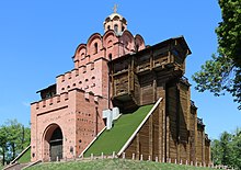
The district is historically significant, as it was here on the Old Kyiv mount where the apostle Saint Andrew erected the cross, also the famous Golden Gate of Kyiv, the main entrance to the medieval city of Kyiv is located in the district, as are the three major churches of the city: Saint Sophia, Saint Michael and Saint Andrew. Furthermore, in this district the first parliament of Ukraine met at the Ukrainian Club Building and declared Independence in 1917.


